Energeo Seis2Kml
Overview followed by Seis2Kml Help and F.A.Q.’s.
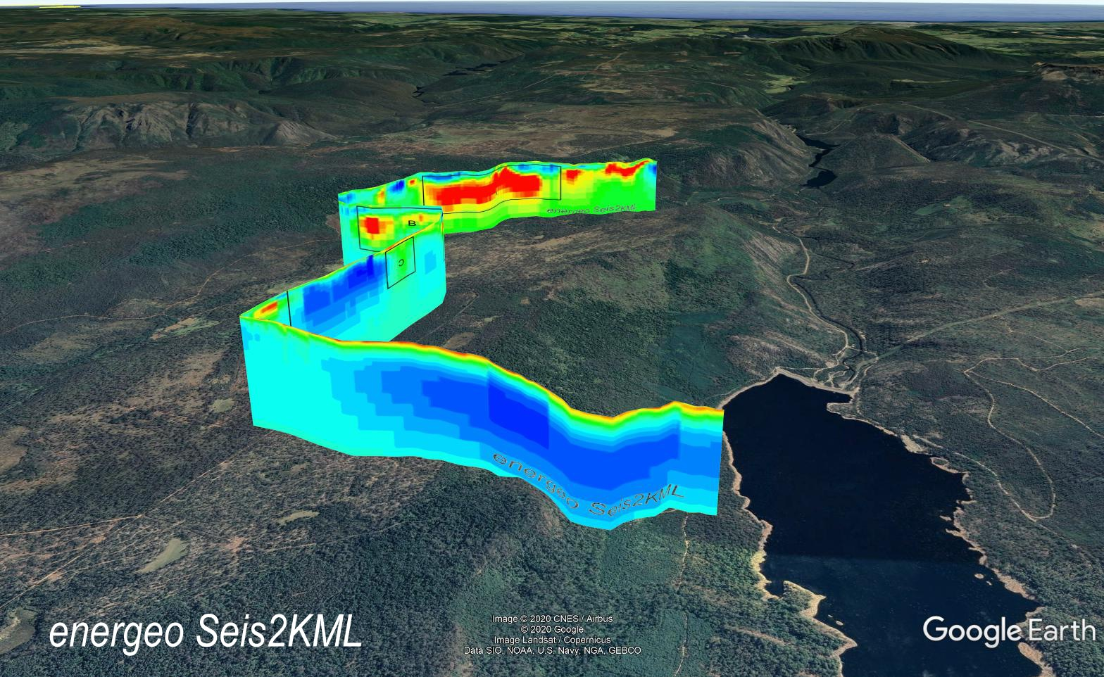
Seis2Kml was written to allow users to quickly make and display seismic images in a 3D space, namely GoogleEarth.
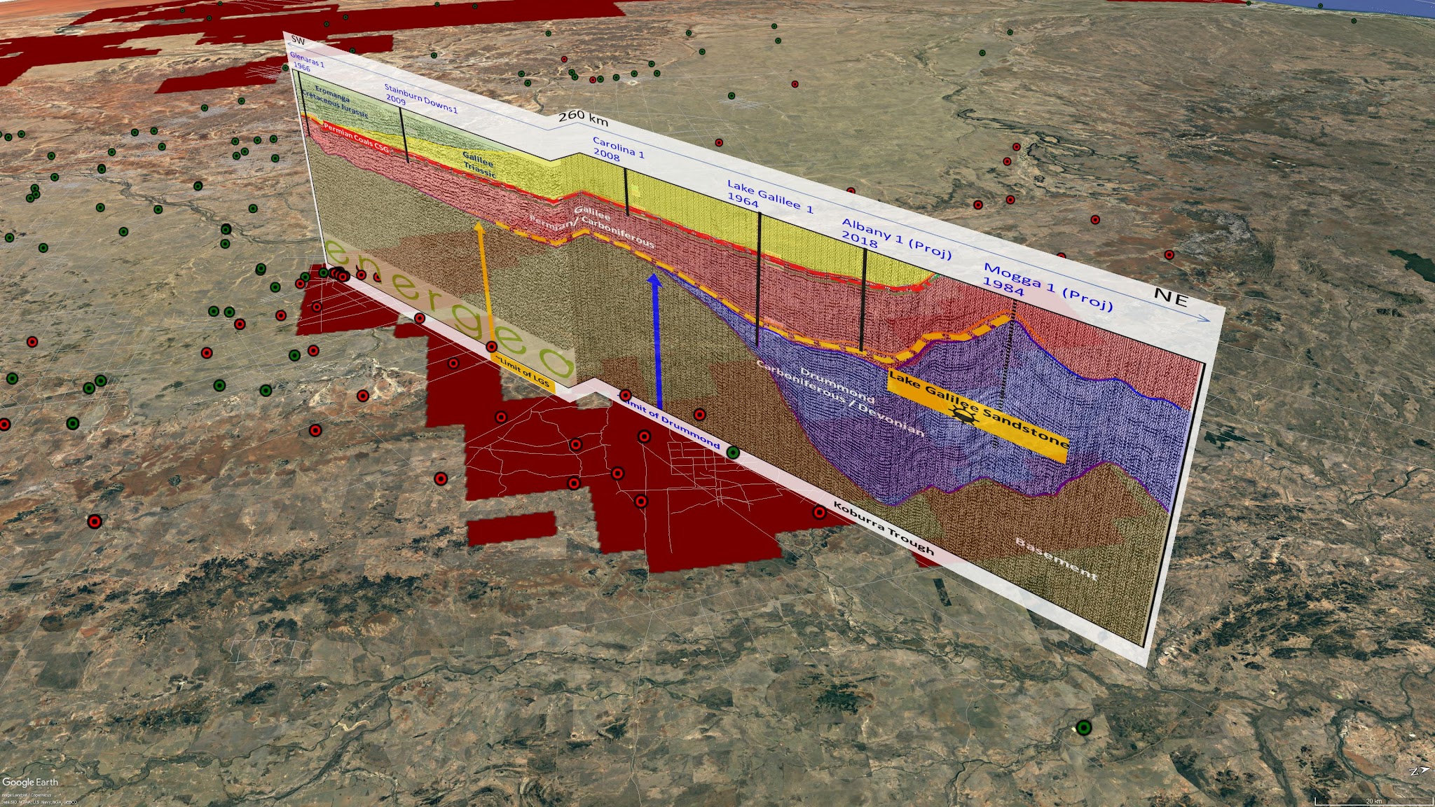
Interpreted Schematic Seismic Section across the Galilee Basin.
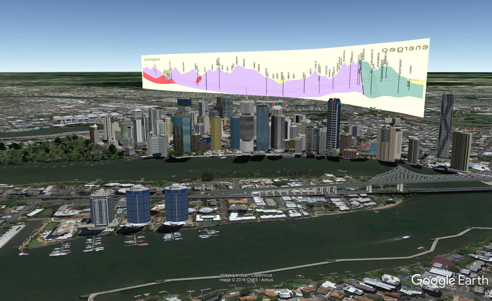
Legacy Way Tunnel Schematic Geological Section across North Brisbane.
Welcome!
Table of Contents:
Quick to Generate!
Using Seis2Kml is simple!
1) Add your X,Y coordinate file, choose a Geo-reference System
2) Add your image file
3) Associate the files
4) Generate
5) Open your new georeferenced image in Google Earth!
Purchase and Install:
Seis2Kml requires Windows 10 (currently tested successfully on 1803,1809 and 1903, both pro and home versions). It also requires access to the Microsoft store and a Microsoft account. In regards to a Microsoft account if you’re in a large company, you may have an Active Directory and, depending on your administrator access level, may need your IT department to install Seis2Kml or any other microsoft application.
If you don’t have a designated microsoft account, you can link another type of account (e.g. ValuedUser@Gmail.com, @Yahoo.com, personal or work accounts etc) to Microsoft and when you redeem your purchase or code it will be linked to that account permanently.
Follow this Link to the store page.
Thank you for purchasing Seis2Kml.
The Microsoft Store will open to the overview page for the app (if on a Windows 10 device), where you can click “Install” to download and install the app. The code will be applied to the customer's Microsoft account, so they can later download the app on other, signed-in, Windows devices associated with the same Microsoft account.
Once installed the app will update automatically unless this is manually turned off.
Launch Seis2Kml directly from the store or through the Start Menu.
Demo Files:
Energeo has supplied some open source SGY Images, coordinates and an image of the Seis2Kml generated GoogleEarth KMZ product.
Download from the drive.google link below; ~18MB and is called “Supplied_Examples.zip”
Link: Seis2KML-SuppliedExamples.zip
This contains seismic lines in the Bowen Basin, Queensland, Australia. The below “Step-by-Step” takes you through creating a kmz file.
The images have been cropped and the coordinates moved to the first two columns. Coordinates are in GDA94 MGA zone 55 (28355).
Step-by-Step:
- Unzip the downloaded files to a memorable location.
- Open Seis2Kml.
- Click the “Add Coordinate files” icon, browse and select your coordinate file/s then click “Open Coordinate File”.
- Click the “Add Images” icon, browse and select your image file/s then click “Open Image File”.
- In the Geo-reference System box add your reference system. GDA94 / MGA zone 55 (28355) or type a shorthand like “GDA 55” and select it.
- Under the “Files” selection pane select the first coordinate line and check the X and Y (Linename if multiple lines per coordinate file and Z values if necessary) coordinate columns and change if necessary.
- Directly under the coordinate line, in the “Files” selection pane, select the Image icon or the ! icon. Check the Line length to see if the coordinates were parsed correctly, edit the Line Name (if necessary), add the correct Image (if necessary), Choose an image order, configure the Top and Bottom Height (m) and adjust Opacity where necessary.
- Directly under the File check line, in the “Files” selection pane, select the cropping area line. If Cropping needs to be done you can do it here. Hold “Ctrl”+ “MouseWheel” to zoom in and out.
- Repeat 6-8 with other files and then click “Generate KMZ” located at the top-right of the page and save the file.
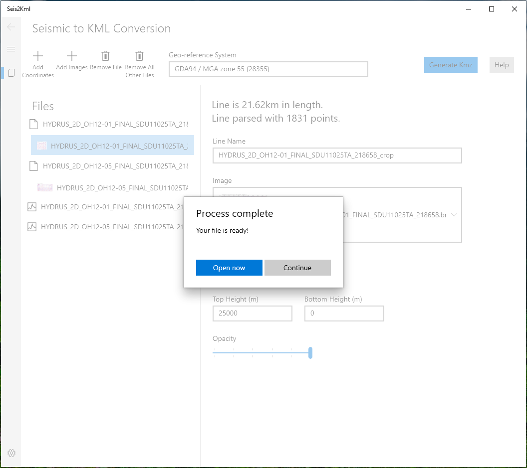
- Let this run (no more than a few minutes), then a pop-up window with “Open Now” and “Continue” should appear. Your KMZ had now been created.
Input File Types:
There are two types of input files; Images (seismic sections) and coordinate files.
Image files can be:
JPG
TIF
PNG (Supports transparent images)
BMP
The resulting KMZ file size is largely determined by the input images. This is important if you intend to email the output files. Otherwise there is no hard restriction on file size. Please contact Energeo for processing more than 50 models at a time.
Cropping:
Often there is a border around the main element of a seismic image or a margin around your figure you want to display. For accuracy’s sake cropping or trimming the edges is required to align the image to the correct coordinates.
Seis2Kml has an option to set the outside borders using the pixel location from your favourite image program. Once a number is entered (tab or click out) a preview of where the produced section will start will appear.
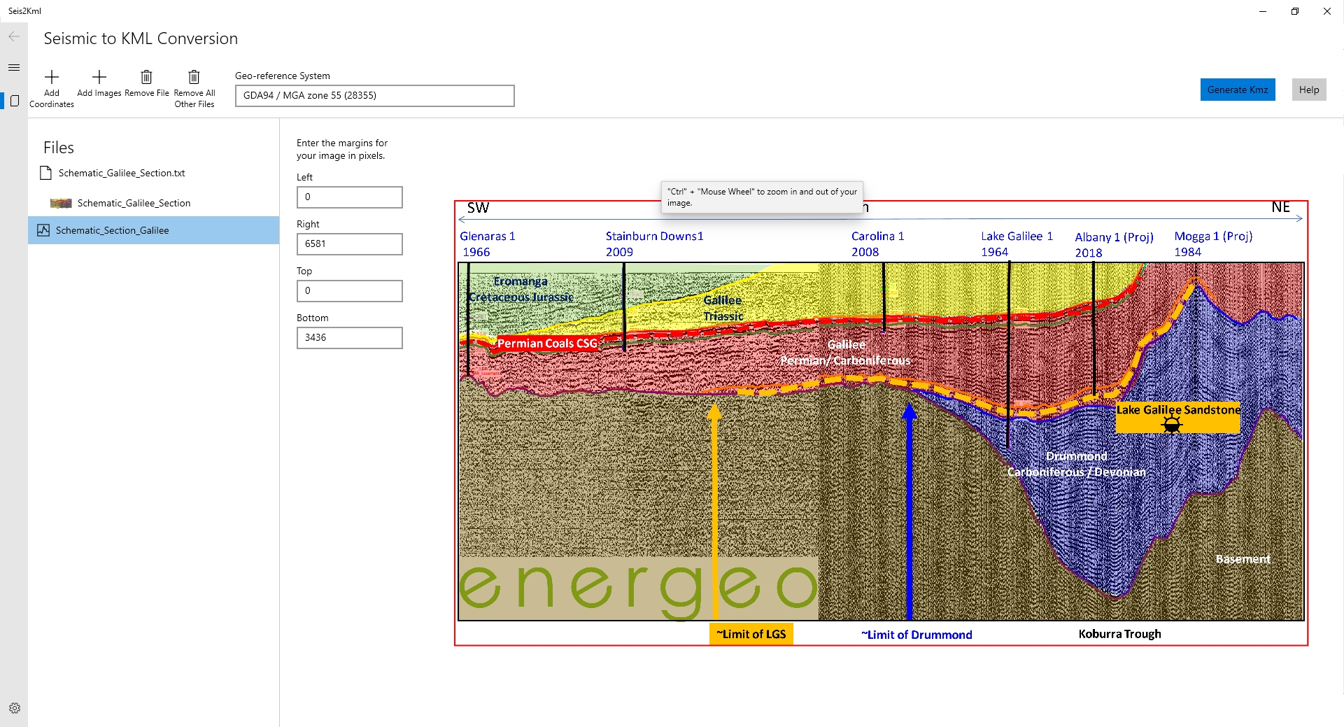
Image cropping using Pixel extents. Red Border showing resulting cropped image.
The program is designed to use the most common forms of seismic location files and variations on those. Files must be delimited text (ASCII) and several example files are included in the Demo Pack.
Delimiters:
Tab
Comma
Space
If you have a specific need of another character to be used as a delimiter please contact support@energeo.com.au.
At this stage the application cannot handle fixed format text.
Typical Coordinate File
Header Line1
Header Line2
Header Line n
Header Line-x
Linename1 Station Easting (X) Northing (Y) Elevation (Z)
Linename1 Station Easting (X) Northing (Y) Elevation (Z)
Linename1 Station Easting (X) Northing (Y) Elevation (Z)
Linename2 Station Easting (X) Northing (Y) Elevation (Z)
Linename2 Station Easting (X) Northing (Y) Elevation (Z)
Linename2 Station Easting (X) Northing (Y) Elevation (Z)
The software uses geo-logic to parse the file into header rows and data rows and identify separate line names. It doesn’t always get this right and the appropriate X Y columns can be selected using the drop down tools. Z columns need to be picked manually. A line needs at least two points
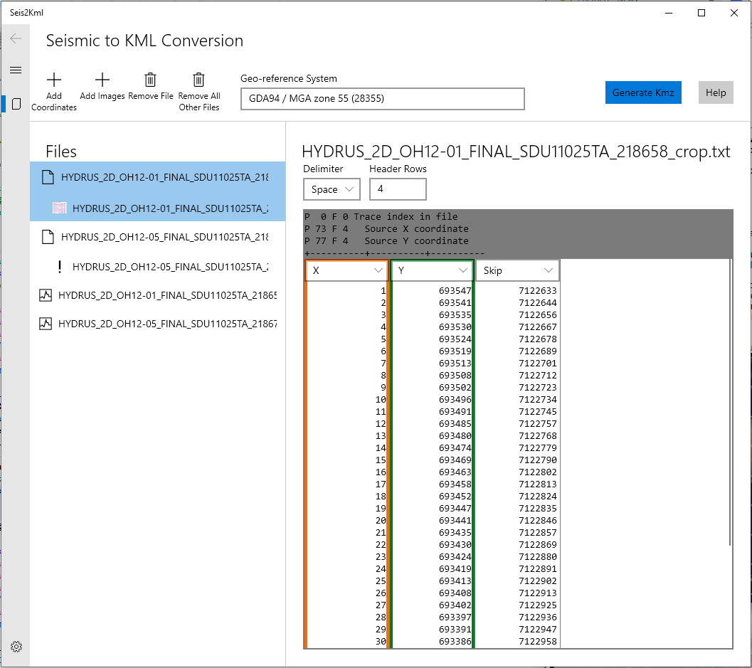
Geo-logic parsed file. The program automatically picked up the 4 headers but treated the first column as an X location instead of a skip column.
There is no limit on the number of files that can be processed but you may run into memory issues for large number of files. You will know this when the program crashes. We recommend restricting the total number of files to <50. Contact support@energeo.com.au for tailored solutions required for large projects. Batch mode allows for a greater number of files to be processed and allows easy re-processing of files.
Notes:
Only one format is supported per input file.
XYZ must be in projected coordinates units such as metres or feet, not latitudes and longitudes
Fixed format not supported, must be delimited.
If your coordinates are scaled e.g. 100 times actual you will need to correct for this outside the program. A later update will add scale factor correction.
It is common for the first or last coordinate in a file to be erroneous such as zero. The software reports the line length, check this for hidden errors.
Coordinate Reference System (or Geographical Reference System)
Typically seismic coordinate files lose their header rows over time.The user is required to know the CRS. In Australia the most common CRSs are UTM projections based on GDA94. The Eastings (X) are commonly between 200,000mE and 800,000mE and the Northings (Y) between 5,000,000nN and 8,000,000nM. Zones can be seen in the below Figure.
Seis2Kml uses a modified GDAL library and this supports most common systems. To find the appropriate code type in some shorthand known about the CRS needed and select from the dropdown list of results.
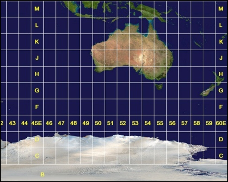
Zones in Australia. Brisbane is located in UTM Zone 56.
Example of shorthand Coordinate Reference system.
Typing “MGA 56” into the box is enough information to narrow down to the correct result.
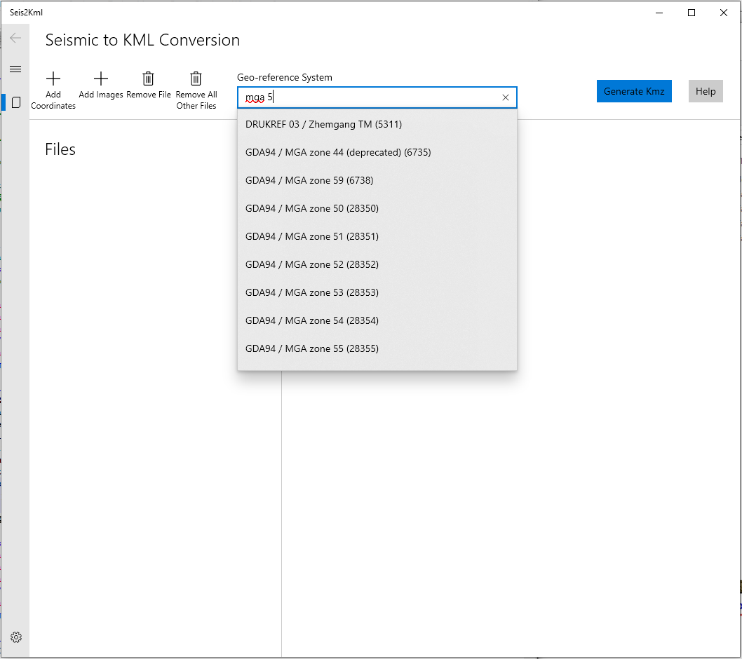
Coordinate Selection using shorthand. This process utilises Fuzzy-Logic matching.
Parameters:
Once the coordinate file is loaded then a parameter line is added for checking files and modifying specifics in the output file:
Line length, Lines parsed(XY pairs), and Coordinate image order:
Seis2Kml calculates the line length (km), counts the number of XY pairs and allocates the first XY point to the left-most pixel in the image.
Line Name: Google Earth has Folder names (which is the filename.kmz) and Model Names. Line Name will update the Model Name in Google Earth.
Image: This is where you choose or override the image to match your coordinates. The image will match on exact file names automatically by default.
Top Height and Bottom Height: Height above ground level you want your image to be displayed. This is technically where you can apply a vertical squeeze or stretch to the image.
Opacity: Opacity slider. Default is 100 (Opaque) and
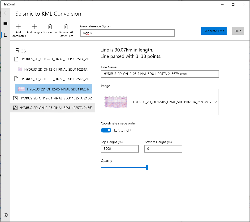
Image file and Coordinate file matching and output modification.
Batch Mode:
Batch Mode is only available in the pro version.
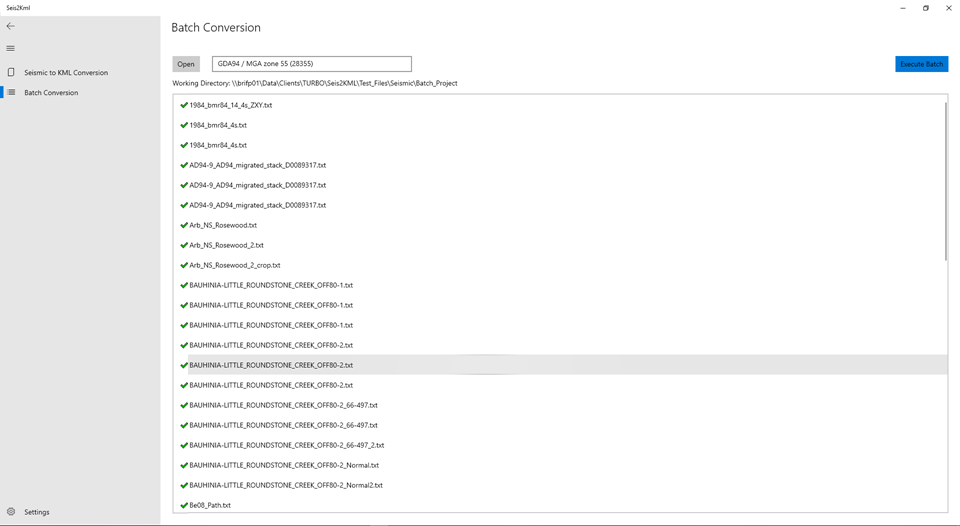
Batch Conversion Interface.
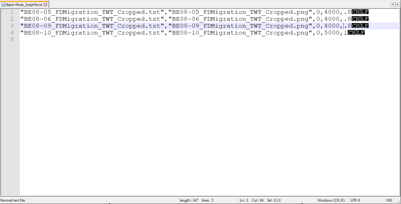
Batch Script example for 4 files
Batch Mode benefits larger organisations with multiple files that require processing or re-processing with different images. This powerful tool allows small changes to be tested or updates to images to be made across many files quickly.
Batch files needs to be written in the following pattern:
CoordinateFile, ImageFile, BottomHeight, TopHeight, Opacity.
Each Coordinate file needs to be refined: X and Y columns only with tabs.
Each Image file needs to be a jpg, tif, png and bmp format.
Example files can be downloaded using this link (same as above):
F.A.Q.’s:
Do I need a Microsoft Account?
Yes. You can also link a non-microsoft account, such as gmail, to Microsoft and use this in Microsoft store.
I have a specialised requirement and the Seis2Kml Interface doesn’t allow it. Can you do unique jobs?
Yes. Contact Support@energeo.com.au.
How accurate is this display?
This application is designed to depict the seismic over an area. The middle of the line is accurate however the ends may deviate and the curvature of the earth is also not taken into account.
How big can the files be?
Image size slows Google Earth but not Seis2kml.
Can I have multiple images per XY coordinates?
Yes, these can be selected on and off in Google Earth.
Can I have multiple coordinates per line?
Technically, yes. This is done by copying the image, giving it a different file name and reimporting.
Can I use multiple Coordinate Reference Systems?
Not through one pass. This can be done by multiple passes and creating a few KMZ’s and loading them into Google Earth. This can be useful in confirming what coordinate system your sections were actually acquired in.
If you have other issues not addressed here please contact support@energeo.com.au
Troubleshooting:
“Have you tried turning it off and on again?” - Roy, IT Crowd, Channel 4 ~2006.
Common issues:
My images aren’t lining up, even without cropping or elevation.
GoogleEarth has a “Terrain” button that affects the elevation at the middle of the line thus affecting the elevation along the line. If you’re going to use Elevation this button needs to on to ensure line follow the ties.
Terrain on: Using Elevations Terrain button should be on in Google Earth and exaggeration set to 1.0
What do the Icon/Symbols mean?
? - Problem: Seis2Kml can’t interpret the file.
+ Solution: Make certain you select the correct file when prompted and it is of the file types listed above.
! - Problem: No image is associated with this line.
+ Solution: Add image/s to the App or, if loaded, associate the image with the txt file. (If the coordinate files and the image files have the same name they will be automatically associated otherwise manual association must be carried out.)
(Image) - Image is associated with a line successfully.
“Freeze” - This usually due to opening a corrupt or incorrect file type.
If there are any further questions, comments or suggestions please email:
Support@energeo.com.au
This page is accessible through the url
www.Energeo.com.au/Seis2KML_HelpPage.html